
The start of the second half of June brought a noticeable change in the country’s weather. Greece and a large part of the eastern Mediterranean are now under the influence of the African subtropical anticyclone, a system that has been appearing with increasing frequency during the summer months in recent years.
This development has already intensified the warm air masses over the region, while limiting the passage of cooler disturbances from western Europe. The question now is whether this pattern will continue in the coming months.
Seasonal forecasts from the major meteorological organizations point to a clear trend: the country is expected to experience a hot and relatively dry summer.
What does the European Centre
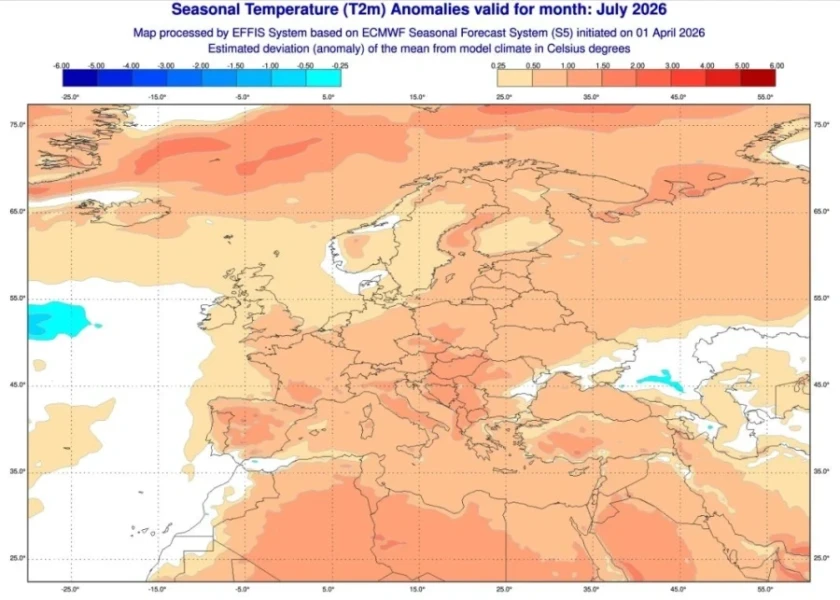
predict? According to data from the European Centre for Medium-Range Weather Forecasts (ECMWF), both July and August are expected to be warmer than the climatic averages.
The strongest heat signals are detected in Thessaly, eastern Central Greece, the Peloponnese, and the islands of the Eastern Aegean.
The frequent influx of warm air masses from North Africa increases the likelihood of periods with very high temperatures. In several cases, maximum temperatures may exceed 40 degrees Celsius on the mainland.
At the same time, the likelihood of more tropical nights is increasing, that is, nights during which the temperature remains above 20 or even 25 degrees, mainly in cities and coastal areas.
Less rain and more drought
The persistence of the anticyclone is also linked to limited precipitation.
Seasonal models indicate that precipitation will fall below normal levels for the season, as most atmospheric disturbances will follow a more northerly path.
The few significant rain events are expected to occur mainly in the form of afternoon thunderstorms in the mountainous regions of Pindus, Epirus, and western and northern Greece.
Data from the U.S. and the role of the Mediterranean
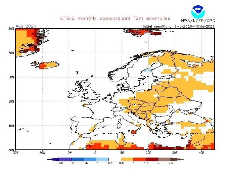
A similar picture is presented by the NOAA models via the CFSv2 system.
The simulations indicate that the subtropical anticyclone will linger longer over the eastern Mediterranean, a factor that increases the likelihood of successive heatwave episodes throughout the summer.
At the same time, data from NASA, which focus on sea surface temperatures, are of particular interest.
Greek seas are already showing temperatures higher than the usual levels for this time of year. This additional heat is expected to affect coastal areas, keeping temperatures high even in the evening hours.
Increased humidity will intensify the feeling of discomfort, especially in large urban centers such as Athens and Thessaloniki, where the heat index will be higher.
Meromienia: Which month is considered the most difficult
In addition to scientific forecasts, many people also follow the Meromenia, the well-known folk method of predicting the weather.
According to this year’s estimates, the beginning of summer is characterized by milder conditions and a gradual rise in temperature.
The picture changes in July and continues into August, when the hottest periods of the summer are expected. Periods of high temperatures are expected to be more frequent, while rainfall will remain limited.
Overall, both international models and traditional forecasts point to a summer of intense heat, few weather events, and increased heat stress in many parts of the country.


